
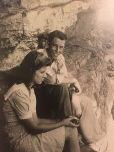
The author’s parents sitting on Indian Walk in the 1940s
In my article last week, I mentioned my adventure down Paint Rock Bluff. It was one of the explorations I probably wouldn’t have done if I had known ahead of time what I was getting myself into. I admit it scared me.
Paint Rock Bluff extends a distance along the north bank of the French Broad River in the Fork, the lands in Knox County between there and the Holston River all the way to the Jefferson and Sevier County lines. The “Indian Walk” section of Paint Rock Bluff is a ledge that locals once frequented; however, the surrounding vertical grounds are now overgrown, making access challenging.
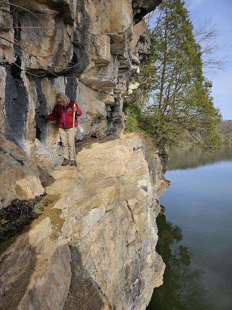
My parents went there as teens in the early 1940s, and someone took their photo. My brother also climbed the site many years ago, so I wanted to go there too. Luckily, the land owner was willing to lead the way, and younger friends, steadier on their feet than my husband and I are, were eager to go with us. Planting our feet on the roots of saplings to keep from being pitched off the cliff and down into the river and literally butt-scooting around outcroppings on the ledge, we made it. I did it, but I won’t go back.
-

- Chase McSpadden, who helped to navigate the steep, rocky landscape and took some of the photos is above ledge
-
- Walking along the ledge after scooting around the outcropping
-

- I made it
The French Broad got its present name from being a wide river initially in French Territory, but the Cherokee call it “Tah-kee-os-tee,” which means “racing waters.” The Cherokee sometimes painted images on stone bluffs, and researcher Fred E. Coy Jr. states in his article included in the book Rock-Art of Eastern North America that some of those images marked a trail or were used to commemorate the heroic actions of a particular person or group.
If local pictographs were anything like those of Minnesota’s border with Canada and elsewhere, as recorded in Michael Furtman’s book, Magic on the Rocks: Canoe Country Pictographs, they were done at canoe level on the river and were probably no larger than a person’s hand, which sometimes was exactly the print made by the ancient artists. Many experts theorize that the images were related to a Native American belief system, perhaps created in relation to a quest for direction or healing. In his 1768 book about Native Americans, early Tennessee historian John Haywood described images of the sun and moon, a man, birds, fish, etc., that were painted on bluffs in the Fork.
The book Scenic Resources of the Tennessee Valley, produced by TVA in the late 1930s, had 100 acres of Paint Rock Bluff listed as a “potential regional recreation area.” It states, “these bluffs reveal good views up and down the river, as well as a glimpse of the Great Smoky Mountains.” Downriver from Indian Walk, today Legacy Parks and land donor Blue Water Industries have established Veterans Memorial Park (KTT article: Veterans Memorial Park ), just off Governor John Sevier Highway on the French Broad across from East Tennessee Veterans Cemetery. With trails and an overlook, the bluff continues to serve as a place of tranquility, reflection, direction and healing. Although the name Paint Rock Bluff continues, the Native American handiwork on the cliffs has since faded, and its history has been forgotten in the Fork.
Jan Loveday Dickens is an educator, historian, and author of Forgotten in the Fork, a book about the Knox County lands between the French Broad and Holston Rivers, obtainable by emailing ForgottenInTheFork@gmail.com.
Jan is a brave lady. When next we see her, she’ll probably be navigating the cave that runs from Chillhowee Park, under the river to Cherokee Bluffs. We know you can prove it does exist, Jan!
LOL! Nope. I’ve heard all kinds of tales, but I just focus on the Fork. I’ll let you tackle that one!