
In the grand scheme, 162 years isn’t long, but in that time, the Black Mountains’ highest peak and the eastern United States’ champ, Mount Mitchell, has weathered discovery, devastation from 100 mph winds, floods and Hurricane Helene together with human greed, politics and eventually conservation as a North Carolina state park.
That 35-mile mountain range known as the Blacks has brought North Carolina much notoriety.
But this article isn’t intended to be a morality play. Today’s Mount Mitchell and environs still thrill explorers. Our July visit there six years ago is solid proof.
The nomenclature of the Blacks has flipped over time adding even more nuance to the area. For instance, did you know that Clingman’s Peak and Mount Mitchell swapped names? The area has a great history also in the realms of North Carolina politics.
Our target six years ago? A creek once called Sugar Camp Fork, site of Elisha Mitchell’s 1857 death – he who named the mountain after spotting it from Yeates Knob (now Mount Gibbes) in 1844.
With the buzz at the time around “Holy Grail” waterfalls like Mitchell Falls on Mitchell Creek (formerly Sugar Camp Fork), this destination was on The List. It’s private land, so we snagged permission. The property on which Mitchell Falls is located is now owned by an LLC whose primary member is Tim Sweeney, of the video game Fortnite fame. Hopefully in my lifetime, those lands on the western side of the Blacks will revert to public lands once again.
Anyway, back we go to July 2019, six months removed from my hip replacement surgery. Our crew began the journey at the Deep Gap trailhead in Mount Mitchell State Park, intending to descend 2,000+ feet to Mitchell Falls. We five were explorer Ashley Hes; photographer extraordinaire Cathy Anderson Lee and her husband, Kennedy Lee; Rock Sprite Kitty Myers and Badger. The planned hiking route was to follow Captain John Podlewski’s route via old logging roads and a “bear track” to the creek. As Robert Burns (distant kin to Cullasaja Professor Scott Burns) warned, though, the best-laid plans can go awry.
On this quest, Badger suspects why. We lost the “trail” in the spruce-fir wilds, and seemingly were pulled creekward by the terrain and unseen forces.
As it turns out, our route mirrored Elisha Mitchell’s fatal detour in 1857. After submitting Black Dome (now Mt. Mitchell), he thought that he’d found a shortcut via a tributary gully to Sugar Camp Fork and onward to the Escota settlement of the famous Wilson family and thus safety.
Big Tom Wilson, a famed hunter and tracker in his own right with his own renamed Black Mountain peak (originally called Hairy Bear), found the remains of Elisha at his namesake falls when he never arrived at Echota. Wilson detailed his account of finding Mitchell in an 1897 Morganton Herald (NC) interview.
We bushwhacked the same PLR (path of least resistance) as did Elisha, eventually emerging on Sugar Camp Fork (now Mitchell) Creek just below a 100-foot+ behemoth waterfall we dubbed Apocalypse Falls. Suffice it to say, not many photos exist of Apocalypse because few humans have been there. After documenting the twisting falls, we proceeded to creekwack downstream to our destination as a thunderstorm overtook us.

Apocalypse Falls – 7.13.2019 (photo by Thomas Mabry)
In his interview, Big Tom remembered that he had tracked Elisha Mitchell’s route. Mitchell entered the creek some 250 or so yards above the falls. My GAIAgps track indicated our descent from the base of Apocalypse to our destination at .37 miles, including that one tributary that we also saw on our journey almost two centuries after Mitchell’s fatal descent.
Was the creek route treacherous? That answer was YES, especially in the storm. Ashley was the most agile of our crew, and she nearly tumbled over one of the drops. We skirted and slid down several cascades, and eventually my hiking pole vanished mysteriously in a dense rhododendron thicket just above the falls.
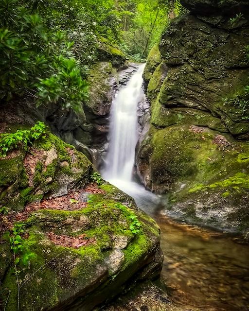
Mitchell Falls – 7.19.2019 photo by Thomas Mabry
But unlike Mitchell’s twilight plunge down to his demise at 8:19 p.m. on June 27, 1857 (the time indicated by his stopped watch also found by Wilson), we had daylight savings on our side, so at least we could see our descent through the rain down the creek. Poor Elisha had virtually no light and could have perished anywhere on the 250 yards above the waterfall. The drops we encountered would have carried him to his final resting spot.
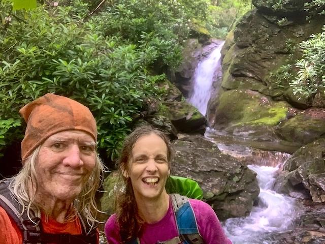
Badger and Rock Sprite Kitty Myers at Mitchell Falls – 7.13.2019 (photo by Thomas Mabry)
When we finally arrived at the falls, we reveled at the historic spot – with selfies, photos and high-fives, and then we began the somewhat saner 2,249-foot ascent on the route that we originally intended to take down to the falls. After miles of ’schwacking, leg cramps hit Badger hard and a decision was made to allow the spry but tired trio of Cathy, Kennedy and Ashley to find an off-trail ascent to our vehicles by 9:30 p.m. when the state park closed.
Kitty and I then slogged 3.5 more or less level but swampy miles on an old roadbed to Stepps Gap, arriving after midnight for a welcome ride from Captain Podlewski and fellow Team Waterfall member Elliott Wilkes to our cabin for the night.
Ironically, both Elisha Mitchell and Badger were the same age – 64 – when we both chose the same route to Mitchell Falls, echoing his historic but deadly path. That lost hiking pole? It was likely taken to allow Elisha’s ghostly nudge to propel Badger to stay sharp and avoid the mistakes that caused his demise.
Richly historic waterfalls definitely have spirits and our crew survived epic conditions to carry on the spirit of adventure to this “Holy Grail” waterfall. This was one day of epicity none of us will never forget.
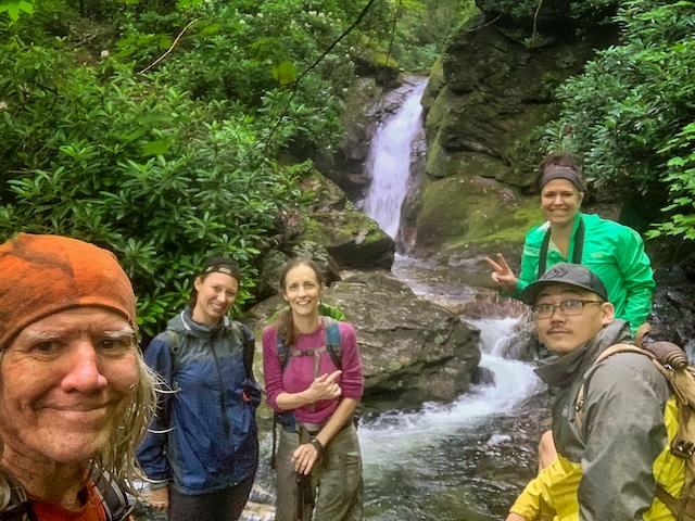
The Mitchell Falls Crew from left – Thomas Mabry, Ashley Hes, Kitty Myers, Cathy Anderson Lee and Kennedy Lee (Photo by Thomas Mabry)
Thomas Mabry – Honey Badger Images
Many of the HoneyBadgerImages are on display at instagram.com/honeybadgerimages.
Follow KnoxTNToday on Facebook and Instagram. Get all KnoxTNToday articles in one place with our Free Newsletter.
Thanks, Tom, for taking me with you on yet another adventure. I tell the story of Clingman and Mitchell as often as Smokies visitors will let me, which is not nearly as often as I would like. Those who listen, though, marvel at the sacrifices made. Now I have visuals to go with the words. You’re the best!
Thanks, Mike, the Mitchell Falls adventure ranks up there with one of the best, especially given the history of Dr. Elisha Mitchell. The interview with Big Tom Wilson was fascinating reading.
Thomas, and fellow explorers, enjoyed your storytelling greatly! The background adventure became alive with your crafting of this historical event. Many thanks for the share.