Winter Storm Fern, a powerful weather event which occurred from January 24-26, 2026, stands out as one of the broadest and most disruptive systems in modern American records. It developed from an intense low-pressure area in the southern plains on January 23. The storm quickly strengthened, covering roughly 2,000 miles from the Southwest to the Northeast – including the Southern Appalachians the next day. Tracked and named by weather experts, Fern delivered a dangerous combination of snow, ice pellets, and freezing drizzle, affecting two dozen or more states.
This weather phenomenon resulted in nearly 50 deaths, widespread power outages affecting more than a million homes, and major disruptions to transportation and daily routines. The storm’s path echoed earlier large-scale disturbances but was heightened by atypical weather dynamics, including rare temperature inversions.
Our mountains bore a significant brunt of Fern’s severity, shifting the area’s usual temperate winter into a harsh, icy challenge. Snow and ice coated peaks like Mt. LeConte while valleys endured debilitating layers of sleet and ice up to half an inch thick.
This event also led to hazardous driving, fallen branches, and extended power disruptions. Plunging temperatures eventually fell into the low teens and below 10 degrees, with gusty winds making it feel even colder, prompting widespread school closures and state emergency declarations in North Carolina and Tennessee.
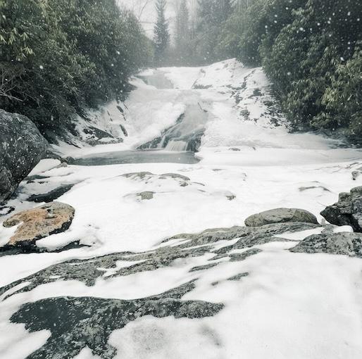
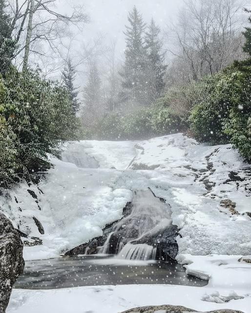
Both Bubbling Spring Branch Falls photos by Thomas Mabry
Fern’s three-day push into the region underscored how our Southern highlands can be hit hard by infrequent but intense cold-weather events, isolating mountain residents and overwhelming local support systems.
Those who know Badger suspected he would engage the storm. They were not disappointed. As a landscape photographer, weather conditions often guide my choices in seeking out scenes that truly represent nature’s moods, and this was indeed the case as I ventured into the gathering morass of Winter Storm Fern.
My aim was to document the beginning of the storm on NC Hwy 215, known to aficionados as Waterfall Highway 215. With snow falling on the highway above the 4800′ feet elevation mark, my target soon became Bubbling Spring Branch Falls, located less than 50 miles from the Tennessee line. Aligning my outing with the storm’s arrival on January 24 and brandishing my microspikes and camera equipment, I negotiated the short but slippery path to the falls, enduring wind gusts and the onset of ice and snow.
After digging in and setting up, I snapped the shutter of my Canon mirrorless camera to digitally record the waterfall’s frosty flow against the initial snowflakes – a vivid emblem of Fern’s approaching intensity. This shot, preserved in the moment, was intended to demonstrate the storm’s blend of threat and concomitant scenic allure by capturing the emotional depth of a significant weather event with an evocative image.
Was the mission accomplished? As defined by the eye of my social media beholders as well as the eye of the storm, the evidence suggests that it was. You make the call!
Many of the HoneyBadgerImages are on display at instagram.com/honeybadgerimages.
Follow KnoxTNToday on Facebook and Instagram. Get all KnoxTNToday articles in one place with our Free Newsletter.
Appreciate your images. You are brave to venture out into the storm.