
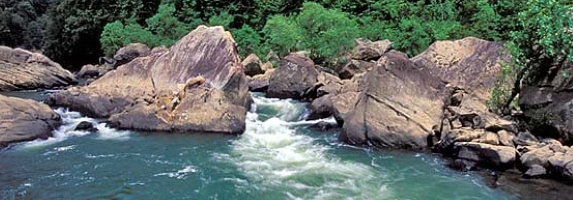
A hop, skip and jump west of Huntsville in Scott County, the Clear Fork and New Rivers meet up to form the headwaters of the Big South Fork of the Cumberland River. It meanders its way north by northwest by north by northeast on repeat for 76 miles until it meets up with the Cumberland River just south of Somerset, Kentucky. It is surrounded by forests, rugged terrain, massive boulders and deep, sandstone gorges, some reaching heights of 600 feet.
On this day 35 years ago, the U.S. Army Corps of Engineers wrapped up their construction of campgrounds, horse camps, overlooks and trails for the Big South Fork National River and Recreation Area and turned the keys over to the National Park Service. It’s a cumbersome name, owing to the name of the river and that it was the first unit in the NPS system that combined a National River and a National Recreation Area. Most folks just condense the mouthful to Big South Fork.
It isn’t just the river, it’s the roughly 125,000 acres across the Cumberland Plateau, most of which is in Tennessee in Scott, Pickett, Morgan and Fentress counties. The remaining acreage is in McCreary County, Kentucky. We have this natural wonder preserved for all to enjoy thanks to our late senator and Huntsville native, Howard H. Baker Jr.
The park was already somewhat up and running by the time of the transfer. It was first authorized by Congress and signed into law by President Richard Nixon in 1974, just a few months before he resigned. The Army Corps was in charge of acquiring land and constructing facilities. The planned completion was delayed due to budget cuts during the first administration of Ronald Reagan, who wanted to reduce the budget to zero. Instead, the budget went from $26.9 million to $9.9 million. Baker’s advocacy eventually got that funding restored.
The moved to hand over management before completion to the NPS was a practical one, and it had to do with funding. The Army Corps could only fund up to 50% for land purchases, with the rest needing to come from local sources. The reality is, Big South Fork was created in extremely rural, mostly poor counties, and the financial resources simply didn’t exist there to fund those additional land purchases. Enter the NPS which could fully fund those purchases. At the time of the transfer, the park was 106,000 acres, the rest came in due time.
Another thing to understand about the area is that, much like the Smokies in the early days of the national park, lots of acreage had been logged to desecration as well as the damage left behind by coal and salt peter mining. By the time the NPS took over in 1991, there were no black bears left on the Cumberland Plateau. The alleged last one was killed near No Business (now a ghost town) in the early 1900s. The loss of old growth trees also contributed to their decline.
By the mid-1990s, 14 female black bears and their cubs from the Great Smoky Mountains National Park were slowly reintroduced to Big South Fork, where they have now reestablished a population. Occasionally elk are spotted with the park boundary, having wandered over from the North Cumberland WMA after being reintroduced in 2000.
When the Smokies seem a little to crowded for you, just head north on I-75.
Sources: National Park Service, Knoxville Journal Digital Archives
Beth Kinnane writes a history feature for KnoxTNToday.com. It’s published each Tuesday and is one of our best-read features.
Enjoyed this article? Read more of Beth Kinnane’s stories about the people, places, and history that make our community unique.
Follow KnoxTNToday on Facebook, Instagram, X, and LinkedIn. Get all KnoxTNToday articles in one place with our free newsletter. Comments may be sent to news@knoxtntoday.com.