
When most area people hear “the Fork” today, they’re probably thinking “the Forks” and envisioning areas at the confluence of the rivers, down where the French Broad and Holston converge to create the Tennessee. The Forks of the River Industrial Park, the Forks of the River Wildlife Management Area and the Forks of the River Park (all established since 1960), likely have contributed to the shift in nomenclature.
Historically, however, the singular term “the Fork” has referred throughout earlier decades to the Knox County lands between the French Broad and Holston all the way to the Jefferson and Sevier County lines. As an example, a 1914 article celebrating the determined location of the proposed new high school tells how “Carter’s” is in the center of the broad part of the V-shaped Fork. Detailed property-related papers throughout time, too, demonstrate how the Fork was considered to include more than just the point at the rivers’ confluence.
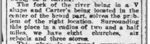
1914 article
Back when I was teaching a Sunday School class of elderly Mascot community ladies in the 1980s, they asked me where I had grown up. When I told them, they commented with an identifier that was new to me, “Oh, you’re from across the river!” Their observation perplexed me. I had never considered the river to be a geographical boundary of significance, but they had all experienced childhoods without the luxury of bridges across the nearby rivers. For older generations, the Fork was remembered as a separate land mass. See last week’s article How It Began.
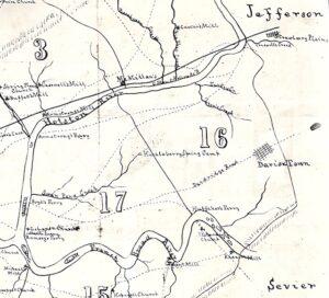
Map of 1870s Fork ferries
Today, we think little of traveling from point to point within our county as we drive across where early bridges were constructed at Mascot (1931), Asheville Highway (1931), Boyd’s (1949), John Sevier Highway (1963) or I-40 (1975), but not too many decades ago, you had to be more intentional about getting to the Fork. Prior to the building of Knox County bridges that span the Holston and French Broad Rivers, the Fork was accessible only by boating, fording or ferrying.
According to research by Tony Holmes, published in the Tennessee Anthropologist in 1991, the ferry crossings that served the Fork began by 1791. They included McBee, Armstrong-Ruggles and Boyd’s on the Holston, and the Huffaker and Bowman-McBee-Hodges ferries on the French Broad, as well as the ferries at the point of the Fork, owned across the centuries by various families such as Anderson, Brabson, Cosby, Gilliam, Jack, Ramsey, Rhea, Thurman, Wassum and Wright.
An 1889 article, describing meetings about a proposed railroad leading across the Fork and into Dandridge, told how the project’s promoters had ferried the Holston, and it identified Huckleberry Springs and Thorn Grove as communities within the Fork. It stated how citizens of Knoxville “have not generally had the pleasure, however, of visiting this section of our county, the land between the Holston and French Broad rivers….”
The railroad venture never materialized and, along with the ferries, is just one more bit of history forgotten in the Fork.
Jan Loveday Dickens is an educator, historian, and author of Forgotten in the Fork, a book about the Knox County lands between the French Broad and Holston Rivers, obtainable by emailing ForgottenInTheFork@gmail.com.
Thank you. There seems no end to interesting history in East Tennessee.
I’m happy to share!
Your interest is appreciated! The railroad was the Knoxville and Northeastern, represented by W. K. Morrison. It was intended to reach the iron ore in the Fork and would have traveled 22-25 miles before exiting the Fork at Knox County’s east/northeast edge. Residents were said to support the idea. Judge O. P. Temple, Ed Kennedy, Esquire, and Dr. Caldwell spoke in favor of it, and Rufus Johnson was in charge of a dinner for attendees. My book, Forgotten in the Fork, tells more about Rufus. For more information, email ForgottenInTheFork@gmail.com.
Thank you for your interesting articles.
In re to the 1889 article, was the RR promoter the McDonald Shea & Company?
James McDonald was a national/international RR
contractor who had bought land from the Moses/Joseph Brooks farmlands in the 1880s, and he had a house at the far west corner of today’s Holston Hills Subdivision.
According to a newspaper article, McDonald built for his neighbor, a bridge at the Boyd’s Ferry in 1894.
Brooks and McDonald Roads end where they intersect with Boyd’s Bridge Pike.
Because of the proximity to the Forks and McDonald’s profession, I wondered if he had been a part of the proposed RR project.
Because of the proximity
I look forward to your writings about the Fork area. The photos are wonderful! I remember my father taking the family across the river on a ferry when I was small. Not sure exactly where it was, but my mind tells me it was at the current Houston River bridge. In reality, I am not sure.
Thank you, Sherry! A few of the ferries were still running until the sixties, so it could have been any of those. I have more information about the ferries in my book, Forgotten in the Fork. Please just email me at ForgottenInTheFork@gmail.com if you’re interested.