We all do it. We whiz up and down the roads of Concord/Farragut never giving a thought as to why the roads have the names they are given. Consider the following road names: Mabry Hood, Smith, Campbell Station, McFee, Herron, Everett, George Williams, Bruce Smith, Boring, Harvey and many more. These roads were named after families that have lived in this area for many years, and some of the generations are still here. And these people were the hard working, independent country folk that contributed to the character and customs of the area.
As far back as the 1940s, before GPS, if you needed to stop and ask for directions, you probably would be told to go up yonder to the four way, turn right just past Paw Everett’s place, then turn right at the Mable Post office, then left at the old Coke sign, and it’s a stone’s throw from there. And they might be cautioned to watch out for the pig crossing, and be sure to yell “Hello the house” before approaching the front porch else you might be met with a shotgun. That’s the way things were.
Local folk often referred to landmarks with names that made sense to them but today would cause some puzzled looks. Ask any old time Concord/Farragut resident and they can tell you exactly where those landmarks are located. The writer thought it might be fun to explore some of these places thus offering a little trivia for newcomers to the community.
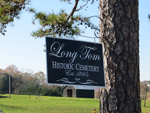
Long Tom Cemetery: Who was Long Tom? There are two people interred in this cemetery by the first name of Tom: Thomas Earl Hall and Thomas Lethgo. But since it is a very old cemetery with only about 20% of the graves marked, there may be another Tom or two abiding there. According to lore, the namesake of this cemetery is supposed to have been so tall that he would not fit in his casket. But time has passed and there are no records as to the true identity of Long Tom. The cemetery is located a half mile west of the intersection of Northshore Drive and Choto Road.
Saltpeter Bluff: An obscure saltpeter cave is located on the banks of Ft. Loudon Lake, just west of Rivendell Way Road and adjacent to Duck Cove Drive. The bluff has an approximate elevation of 889 feet above sea level and was once used during the Civil War for mining saltpeter which was used to make gunpowder. This location was ideal because the Confederates were able to avoid detection of the mine. In later years, it was also useful for a local person who hid in the cave for several months to avoid arrest from the law.
Rose Hill Curve: Rose Hill curve is located just east of Everett Road on Kingston Pike, in the vicinity of Primrose School of Farragut. In earlier years, Rose Hill Tavern sat in the woods and was a popular place during prohibition. Because of the slope and curve of the highway, it has been the scene of many very bad traffic accidents. But one wonders who is the Rose for whom the tavern was named?
Possum Valley: Possum Valley was a small rural community that was close to the fine homes on Northshore Drive now known as Montgomery Cove and Jefferson Park. The residents were farmers, but the area boasted two churches, a country store and a one-room schoolhouse named Boyd School. It is thought that Possum Valley was named because Union Gen. Ambrose Burnside’s soldiers wrote in their diaries as they camped there that if it had not been for the possums, they would have starved to death.
Today, try asking GPS: “Navigate to Possum Valley” or Alexa: “Give me directions to Long Tom Cemetery avoiding Rose Hill Curve.” The answer might be “You just can’t get there from here!”
Mona Isbell Smith is a retired computer systems analyst who enjoys freelancing.


